6.2 Data Input Procedures
Tabular Data
Data entry is carried out using an application tailored to the questionnaire. The application has been developed in FoxPro for Windows version 2.6a, which is downloadable from The Microsoft Website for free. The application has been compiled into three executable files: L1.EXE (0.8MB), UTILS.EXE (0.9MB) and QUERIES.EXE (2.2MB). The system accesses four major data files: (1) Villages, (2) Suspected Mine/UXO/Cluster Bomb Areas, (3) Victims and (4) Errors.
Two files contain the scoring set-up variables: (1) weights and (2) ranges.
In addition six data dictionary files are accessed: (1) Provinces, (2) Districts, (3) Communes, (4) Villages, (5) Map sheets and (6) pop-up menu data dictionaries.
To simplify queries, the data entry application generates a Victims statistics file that is automatically updated during data entry, or can be entirely regenerated using a system maintenance module.
This data entry application replaced the recommended IMSMA system, which was found unsuitable for various reasons for the conditions of the Cambodian Level 1 Survey and the strict quality assurance/control requirements defined by GeoSpatial International Inc. An export/import routine has been developed to seamlessly transfer data between this data input system and the IMSMA Field Data Module.
The Cambodia L1S Data Entry System is described in this section and in
SOP 16:
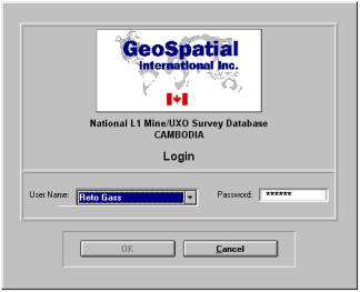
Login Screen
From the login screen, the application can only be accessed with a suitable password. Passwords were issued only to data entry staff and the system administrator (Database Manager).
Successful Login opens the summary screen, shown next:
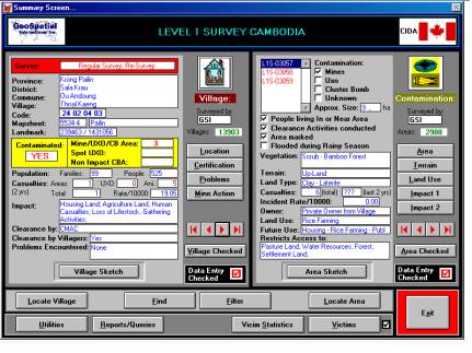
Summary Screen
The Summary Screen displays on its left side a survey summary for the active village and on its right side the list of contaminated areas in that village and a survey summary for the active area. It allows branching out into data entry/edit screens, navigation tools, system tools, reports and allows viewing of associated village and area sketches respectively. These controls are included in the menu buttons at the bottom of the screen. For sketch displays, the application shells out into the “Img Viewer / 32 program.
Data Entry/Editing Screens
The application branches into nine Data Entry/Editing screens, each screen representing a specific page of the questionnaire:
|
Files
|
Questionnaire
pages
|
|
|
|
|
Village
File
|
·
Community
Identification
|
|
·
Certification
|
|
·
Village
Problems
|
|
·
Mine
Action in Village
|
|
Suspected
Area File
|
·
Contaminated
Area Description
|
|
·
Terrain
|
|
·
Land
Use
|
|
·
Impact
1
|
|
·
Impact
2
|
|
Victims
File
|
·
Victims
|
The Village Location and Area Description Screens allow appending new villages and contaminated areas, respectively. The same screens control the deletion of records. This function is only accessible to the System Administrator via password.
All changes to the file are made in memory. The operators need to click a SAVE button in order to save the data to the files. The CANCEL button cancels all changes made to the data. Selection of SAVE triggers a Quality Check Module which inhibits the saving and access to the following Entry Screen if data are missing, illogical or outside a defined range. The System Administrator can override the block. In such cases, or more generally, whenever the field report differs from the data in the file an Error/Correction file can be accessed from each screen where the changes made by database are described.
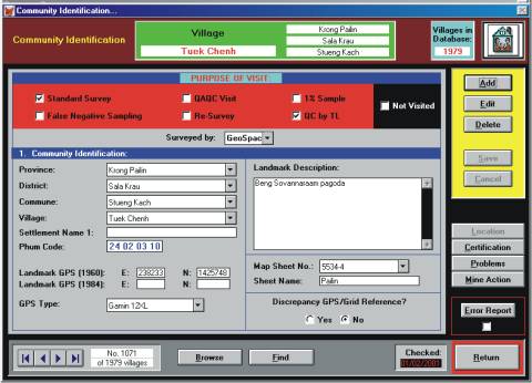
Community Identification Screen
A Record Finder, File Browser and Scroll Buttons allow fast navigation through the records.
Navigation Tools
Several navigation tools are provided to find efficiently specific information. Simple
Scroll Buttons are provided with each screen that allow skipping from record to record in both the village and the Area data files.
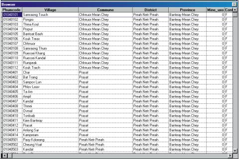
Browse Screens
Browse screens (read only) provide a different way for locating village or area records.
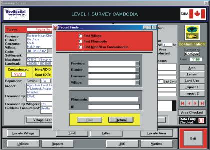
Record Finder
Record Finder finds a specific Village name, Village code or Contaminated Area ID.
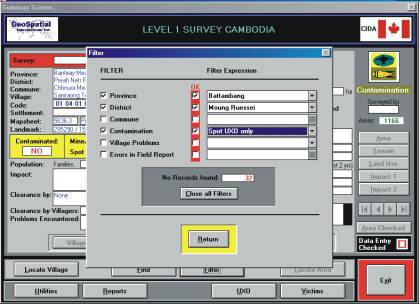
Filters
A Filter Tool limits accessible records to those only, which satisfy the filter conditions
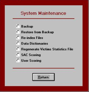
System Maintenance
System Utilities offer a few simple tools for:
- File back-up and restore
- Re-index files
- Maintenance of data dictionaries
- Regeneration of victim statistics file
- Set-up for SAC standard and User defined village scoring.
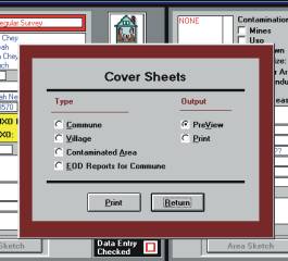
Utility Menu
In addition, printing of English language Cover Sheets can be initiated through the Utility Menu. English language cover sheets presenting some selected key data, are essential to foreigners since field reports are produced in Cambodian language and script. Cover sheets are attached to the following parts of the field reports:
- Commune
- Village
- Contaminated Area
- EOD Tasks
System Utility Menu
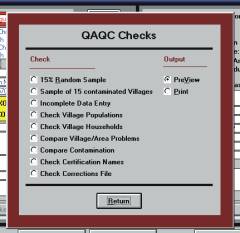
Finally a set of QA/QC Checks (reports) can be initiated through the System Utility menu. These checks extract:
- 15% random samples from the files
- Look for missing data
- Compare Census population and households figures with those collected in the survey
- Extract logical contradictions in the data set
- Allow editing of Error/Correction files
Map Data
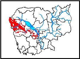
Map data are updated using the Geographical Information System (GIS) software ArcView version 3.2a. One specialized GIS operator maintained four themes of map data:
- Mine/UXO field polygons
- Buffers around polygons
- Mine/UXO field center points
- Benchmark points
This task is accomplished using the following tools:
- Village and Area Sketches provided by the survey
- Village file maintained with FoxPro
- Vector data obtained by the Department of Geography of the Council of Ministers
(Boundaries, roads, rivers, village points)
- Scanned map sheets
- Landsat 7TM geo-referenced satellite imagery
Using the editing functions of ArcView and the above tools, information of the sketches is digitized into the maps. To each mine/UXO field a visually selected center point is assigned
which represents the polygon in small-scale maps. The digitized fields are verified against Landsat imagery or aerial photos, since map sheets of Cambodia are 30 years old.
The following fields in the attribute tables are updated:
- Mine/UXO field polygons
- ID of contaminated areas
- Class (1=area verified, 2=area not verified, 3=area at Thai/Cambodian border [K5 belt]), 5=impact Cluster Bomb Areas (CBA)
- Map sheet number
- Mine/UXO field center points
- ID of contaminated area
- Grid Reference (east and north)
- Benchmark points
- ID of associated contaminated area
- Village code
- Benchmark number
- Grid Reference (east and north)
- Benchmark description
- Distance and bearing from benchmark to suspected area
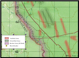
In small-scale maps, contaminated areas are represented by their center points. In large-scale maps, areas are shown in their reported shape. In order to emphasize the uncertainty of the shape and extent of L1 areas, the outline of the polygons remains hidden. Depending on the class of the area (verified/unverified/K5 belt), areas are displayed in different colors and in addition, external buffers of
different extents (100-300m) are added to the polygon. These buffers are displayed with fading-out colors.
The GIS Operator scans all village and area sketches. Village sketches are named with the village code, area sketches with area ID.
Quality Assurance and Quality Control
Several QA/QC controls are built into the Data Entry System:
- Smart Interface
- Minimum of typing
- Error Trapping and Documentation Prevention of duplicate entries
- Prevention from forgetting to enter a report or part of the report into the database
- Reconciliation between operational reports and data entry logs
- GIS QA/QC controls
1. Smart Interface
A smart user interface prevents data entry staff from forgetting to enter information or prevents them from entering information into
the wrong fields.
The application automatically activates/deactivates access buttons to data entry screens and ensures data entry staff sequentially enter information from the field reports page by page. A data entry screen only becomes active once the preceding screen has been entered and successfully saved. These buttons are also controlled by specific survey information. Screens that concern only contaminated villages and areas only become active once a village has been declared contaminated.
The application also activates/deactivates (and blanks fields) when a question branches into different options of further questionnaire questions depending on the answer selected.
Smart Interface
2. Minimum of Typing
Efforts were made to limit typing of text into the files to a minimum. Most fields are populated by mouse click. Typing has been reduced solely to the description of landmarks and to options OTHER when the questionnaire information has not been added to options accessible in pop-up menus. Pop-up menus are populated with updateable data dictionaries.
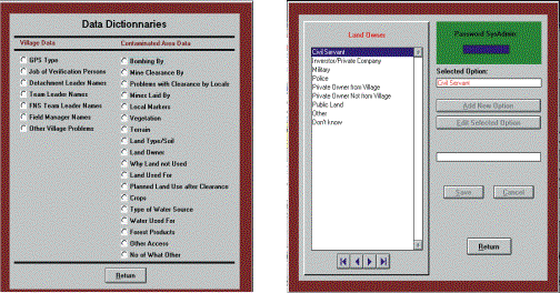
Data dictionaries are accessible through the Application Utilities and can only be updated by the System Administrator. Location pop-up menus (provinces, districts, communes, villages) are interactive and display only relevant options. The location code is automatically extracted from the national gazetteer. The screen allows access to other village questionnaire pages.
Minimum of Typing
3. Error Trapping and Error Documentation
Data entry screens need to be updated and saved one by one. Saving of
entered data can only be accomplished after the application has checked for:
(i) bad info (e.g. Grid Reference outside Cambodia),
(ii) missing information (missing in field report or missing due to data entry error) and
(iii) logical contradictions in data file (e.g. Any casualties)
č YES; How many casualties č N0.
In such cases data can only be saved to the file after the System Administrator overrides the system block with his password.
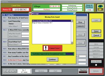
Error Trapping
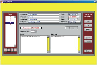
Any differences between field reports and database files are documented in the error file, which is accessible from all screens. The error file records the village, area ID, the questionnaire question number, the problem found and the solution adopted.
4. Prevention of duplicate entries and duplicate Area IDs
When new villages are appended to the data file, the application checks first for duplicated data before allowing it to be saved. Area IDs are generated automatically by the application. If a contaminated area is entered more than once, this is trapped by the GIS, which links area polygons with the area file.
5. Prevention of forgetting to enter a report or part of the report into the database
Villages are entered into the database even if they were not visited by the survey (false negative sampling or other reasons). Such villages are tagged with “Not visited”. There are two possible reasons for a non visit;
- No access was possible (reported for two villages),
- Not visited for False Negative Sampling (0 villages as FNS procedures were not applied in the Survey).
Reports are processed for data entry and final filing commune-wise. After data entry has been completed, village reports of a commune are pooled and clipped together. A cover sheet for this commune lists all its villages (according to the gazetteer) and associates them with basic survey information. Villages found in the gazetteer, which are missing in the survey files are made recognizable by associating them with the tag “Missing”.
Two methods are built into the application to ensure that all report pages have been entered into the database.
Sequential page by page data entry is enforced. A built in QA/QC report lists villages with incomplete data entry.
6. Reconciliation between operational reports and data entry
Five working days per month are reserved for reconciliation. We aim at 100% reports checked. Checked records in both the village and area files are date and name stamped.
7. GIS QA/QC controls
These quality checks ensure that geographic data concerning contaminated areas are complete and adequately precise. All checks are carried out by the System Administrator. These checks aim at processing 100% of all contaminated areas. The procedure traps erroneous GPS readings, quality of digitizing and lost data in GIS files (areas, benchmarks).
GIS QA/QC Controls
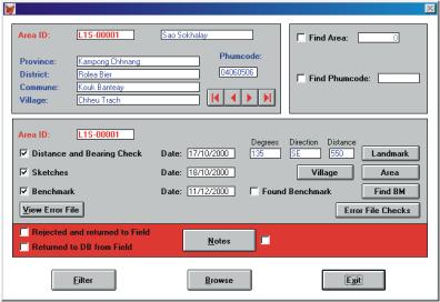
A first check measures bearing and distance between village landmark and contaminated area. Figures obtained from digitized data are compared with those reported in the questionnaire.
The second check ensures that all sketches have been scanned.
The last check compares digitized data, especially the relative position of the landmark, area benchmark, village point, and area, with the sketches.
Maintenance of Hard-Copy Files
Field reports are processed by a defined sequence of action by database staff. Once processing is completed, the pages of the field reports are re-arranged, pooled and clipped together commune-wise and finally filed by Province, District and Commune in lockable steel cabinets.
Reports are re-arranged as follows:
- Pages concerning village information (and stored in the village database file) are separated, village-wise and stapled together with a English language cover sheet. All village reports of a commune are pooled and held in one place, together with a commune coversheet .
- Pages concerning contaminated areas (and hence stores in the area database file) are processed correspondingly with an area cover sheet.
- EOD task reports are not entered in the database. They make up the third set of report pages in a commune folder. The 3 sets per commune are clipped together and filed.
At a later stage all report pages are scanned into Adobe Acrobat files. The digital version of the reports are stored on CD-ROM. One copy remains at the survey headquarters while the second is outsourced to the local office of the Canadian International Development Agency (CIDA).
Security Issues
Data security is managed in the following way:
- All database computers are equipped with two hard disks. Backup of data files is executed automatically by the survey application, each time the application is exited. Exiting the application copies the data files into day-specific directories on both hard disks. They are therefore overwritten once per month.
- A second set of backups is generated at the end of every working day onto ZIP disks.
- All files of the workstations are merged into master files on the System Administrator computer. These master files again are backed up in day specific directories on two hard disks.
- All master files, scanned sketches, scanned reports are copied once per week onto a spare computer.
- The entire system, including GIS files is backed up to CD-ROM at least once a month, or when a province has been completed. Again, 2 sets are created. One remains at the survey headquarters while the other is outsourced to the local office of CIDA.